GIS moving county forward
Many things that happen in this county take place behind the scenes and the citizens are rarely exposed to some of the elements that really make this county tick.
Franklin County’s geographic information system (GIS), housed at the Franklin County Highway Department office, is one of those things. It’s rarely heard about but it has already proven to be an invaluable tool and one that is coveted by surrounding counties and cities.
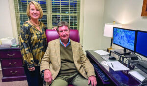
The county’s GIS manager, Michael Hughes, described the system as a set of hardware and software used to collect, analyze and present information about Franklin County.
“In simpler terms, we can use GIS to create a digital model of Franklin County, or a ‘virtual’ Franklin County,” Hughes said. “Once we have the model, we can plug in a limitless amount of information to help us answer questions and ‘what if’ scenarios.”
Hughes said he had plugged information obtained at the Franklin County Revenue Commissioner’s office into data tables, so they were able to see who owned each parcel of land in the county. Information obtained during the last census and information about different utilities are examples of other kinds of information housed in the system.
“If a certain company is considering moving to the area and they want to know what kind of demographics they could expect from the local workforce, we can use the information from the census to find out how many people with a high school education live within 30 minutes of where the company is wanting to locate,” Hughes said.“We can also use topographical information to find out how much water will accumulate in a certain area if an inch of rainfall falls within an hour’s time. Knowing where flood plains are is very important to people looking to buy land.”
The topographical information as well as the aerial view of the county is provided by a company who does a flyover of the area and takes pictures with high-powered digital cameras. This flyover insures the information in the GIS is absolutely accurate to the correct latitude and longitude of any given point.
To illustrate the accuracy of the county’s GIS, Hughes compared the system to a program many people are familiar with, Google Earth. When using Google Earth, a person can see an exact place on a map and can see aerial views. However, if you type in an address, it will not pinpoint the exact address you are looking for.
“Keying the address for my office here in Russellville into a certain commercial map yields a location 1,700 feet from where my office actually is,” Hughes said. “Keying that same address into the county GIS yields a location that is around 20 feet from the driveway of the office.”
County engineer David Palmer said this close-but-not-completely-accurate information was similar to what the county had prior to the last three years with the E-911 system.
“The GIS that E-911 used had a map with roadway center lines, but those lines weren’t completely accurate,” Palmer said. “It was useful at the time, but the technology has expanded and now our county can have that accurate information.”
Palmer started the process of bringing a GIS to Franklin County about three years ago. Before that time, Palmer said he knew about GIS but he didn’t have the intimate knowledge of the wide range of uses it had for a local government.
“Years ago, GIS was used by the bigger municipalities who had more resources than we have, but that started to change about 10 years ago when the revenue office at the state level started an aggressive program to bring GIS to the local level,” Palmer said. “They realized the importance of GIS and what it could do.”
Once awareness about the benefits of GIS started to trickle down, Palmer knew it was something Franklin County should have, but something that sophisticated wasn’t going to come cheap and it wasn’t going to come easily.
“The first thing we had to do was build a base map, which would be the foundation of the system,” Palmer said. “This is where the flyover came into play because the base map is dependent on aerial imagery. But having [a flyover] done isn’t cheap. We knew we were going to need help financially if this was going to work.”
At that point, Palmer met with several other groups who would be able to benefit from an accurate GIS and eventually formed a consortium that includes 14 organizations today.
“Any one unit could not afford to undertake this by themselves because it would be too expensive,” Palmer said. “It only made common sense to share the cost because we would all be using the same map.”
Bringing a sophisticated GIS to Franklin County wasn’t something that happened overnight, but Palmer said the process has been well worth it since they have experienced such positive results, especially in reference to the recent tornado disaster.
Hughes said the county’s GIS played a major role in the search and rescue, the recovery process and with FEMA and other agencies.
“After the tornadoes hit, we went out the following week and classified the damage with handheld GPS devices,” Hughes said. “We did a flyover of the county and now have before and after pictures of what the devastated areas look like.”
Hughes said this information allowed them to see where debris had landed and helped with the search and rescue and the clean-up process. They knew who owned the properties that were destroyed and if someone was still missing, they knew a general location of where to locate them.
“When FEMA had a meeting the following week in Phil Campbell, they needed to know how many homes within the city limits had been destroyed,” Hughes said. “I was able to call them back in two minutes and tell them 137. We were the only ones in the state a that time that I know of that had those kinds of capabilities and had paths of the tornadoes.”
Hughes said in the few weeks following April 27, they worked 17 hours per day helping agencies from the federal level down and were even able to help neighboring counties who didn’t have the same technology.
“The GIS helped people qualify for FEMA’s clean sweep program where debris could be removed from personal property and not just the right of way,” Hughes said. “To qualify, a property had to meet certain criteria and we were able to provide visual justifications for why someone’s property should qualify. It really eliminated a lot of legwork. and saved lots of time.
“Even though the work is minimal now, we are still helping with the tornado recovery and providing information when it’s needed.”
Palmer said the success of the GIS Consortium and the county’s model for a small, rural community has led to recognition for the county at the state and federal levels that eventually translated into grant money.
“It’s a very unique situation to be in, especially for a small, rural county,” Palmer said.
Going forward, Hughes said they hope to develop a web application that would be accessible from mobile devices as well that gives the public at large access to information found in the GIS databases.
“This move would put people in touch with what’s going on in the county,” Palmer added. “For instance, if the county or one of the cities was planning to do construction on a certain road one day next week, we could put an icon on that road and when people clicked on the icon, they could see what kind of work was taking place and how long it would last. They could plan a different route to work or school or home. It would be a huge communication tool.”
Until this application is ready, Hughes said they plan to move forward with compiling data so they can aid local economic development and the quality of living.
“We will be continually improving our data so the GIS can be even more effective in the months and years to come,” Hughes said.


